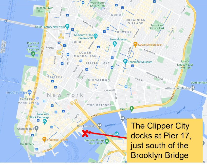
THE CLIPPER CITY TALL SHIP now departs from Pier 17 at 89 South Street, NY, just south of the Brooklyn Bridge.
FOR TICKETING AND CHECK-IN: Visit our dockside staff on the pier starting a half hour prior to the day’s first departure.
Location
In the heart of Lower Manhattan. Just below the Brooklyn Bridge. It’s easy to get to the Clipper City at Pier 17 at the Seaport by foot, train, ferry, bus or car.
Please allow up to 20 minutes to locate the Clipper City dock if you are not familiar with the area.

Boarding
The Gangway to board the Clipper City is at the end of Pier 17 at The Seaport.
You can find the end of the Pier in a mapping tool at GPS:

How to Get There
Google Map
SUBWAY:
The A, C, J, Z, 2, 3, 4 and 5 trains all stop at Fulton Street.
The Seaport is just a few blocks east, towards the East River.
The E train stops at Chambers Street-World Trade Center. The Seaport is a 10-minute walk from the station.
PATH: Take the PATH train to the World Trade Center stop. Walk SE down Fulton Street towards the water until you reach The Seaport.
TAXI/CAR:
Point your GPS towards Fulton & South Streets, New York or to 89 South Street, New York
A block or so away, you can arrive at the Seaport District NYC 19 Fulton St, New York, NY 10038
The Gangway to board the Clipper City is at the end of the Pier.
You can find it on a mapping tool at GPS: 40.705130, -74.001120
PARKING:
Nearby Parking at 294 Pearl Street – entrance to the lot is located on Peck Slip and Pearl Street.
BUS:
Take the M15, QM11, QM25 or X15 and get off at Water Street and John Street.
Take the X8, X14, QM7, QM8, BM1, BM2, BM3 or BM4 — get off at Water Street and Maiden Lane.
From both stops, walk towards the water until you get to The Seaport.
FERRY:
The NYC Ferry stops at Pier 11/Wall Street. Walk north along the waterfront until you get to The Seaport.
